MOAB / ARCHES NATIONAL PARK - Part 2
and, Following The Yellow Brick Road
I apologize for the long wait between posts. We returned home from the first part of our sabbatical for a short visit and have been traveling again, this time to Wales, so I have been distracted from finishing up the last post from Arches and the remainder of our road trip home through the mid-west.
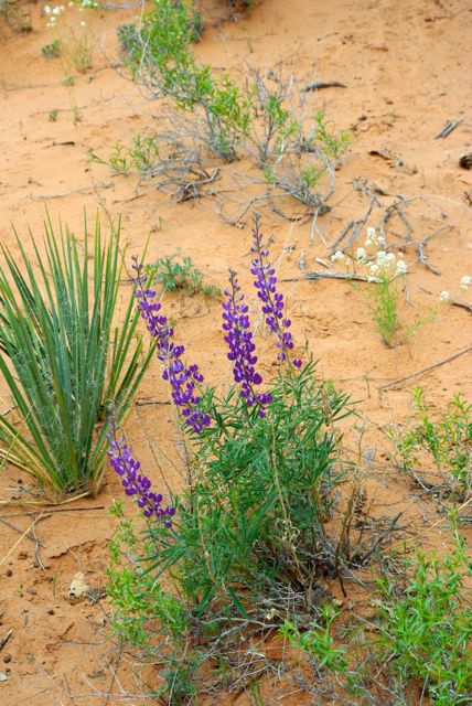
To pick up where I left off in my last post...........after our hike along the Devils Garden Trail, we got back in the car to drive to some of the other highlights in the park. One thing that stood out to us so much was the intense color of everything in the landscape. The sky, so blue.....the contrasting colors of the earth. We had to stop the car constantly to get out and just look at the stunning expanse that surrounded us. There is something so spiritual about this landscape. Being here is good for the soul.

We thought this rock formation looked just like a hand coming up out of the ground. Maybe the hand of an American Indian chief rising up out of the ground to greet us, saying "How" (or "Howgh" used as a greeting by the Sioux) :o)

Courthouse Towers

Tower of Babel
 How much bluer can that sky be!?
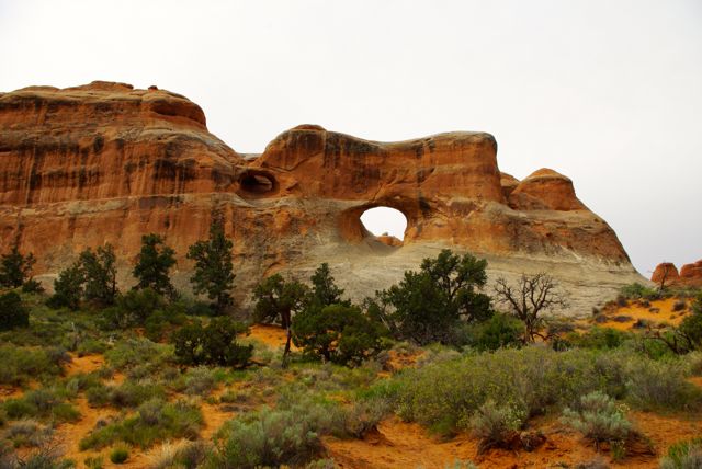
Do you see what we see?
 This just has to be an ancient Indian Goddess. How nature could have created this image is truly amazing. It was HUGE.

and, Following The Yellow Brick Road
I apologize for the long wait between posts. We returned home from the first part of our sabbatical for a short visit and have been traveling again, this time to Wales, so I have been distracted from finishing up the last post from Arches and the remainder of our road trip home through the mid-west.
To pick up where I left off in my last post...........after our hike along the Devils Garden Trail, we got back in the car to drive to some of the other highlights in the park. One thing that stood out to us so much was the intense color of everything in the landscape. The sky, so blue.....the contrasting colors of the earth. We had to stop the car constantly to get out and just look at the stunning expanse that surrounded us. There is something so spiritual about this landscape. Being here is good for the soul.

We thought this rock formation looked just like a hand coming up out of the ground. Maybe the hand of an American Indian chief rising up out of the ground to greet us, saying "How" (or "Howgh" used as a greeting by the Sioux) :o)

Courthouse Towers

Tower of Babel

Do you see what we see?


The Great Wall

A group of saints having a conversation?

Here is a little more on the history of these rock formations:
Entrada Sandstone began forming here more than 150 million years ago as tidal flats, desert, and beach deposits. Over time, layers of rock, perhaps a mile thick, covered these deposits. Tremendous pressure from these rock layers compressed the buried sand into sandstone and cracked it. Erosion then removed the overlying rock layers and the Entrada began to weather.
Within the past two million years, erosion of the cracks in the Entrada has left vertical slabs like the ones seen throughout the photos in this post. These slabs, called fins, are the first step in arch formation.

The Park Avenue formation (named for its resemblance to the sky scrapers in NY), seen here, is a perfect example of this phenomenon.

Beware the Velociraptor!

This whole region around the Arches National Park is dotted with archeological dig sites, so there are many dinosaur surprises all around the area. The Velociraptor just happens to be my favorite dinosaur (I love how they work as a team to stalk their prey - in the movies anyway :o) so I made a radical lane change to get to this guy so I could have a few words with him............
...........Grrrrrrrrrrrrrrrrrrr!!!

 As we passed through Grand Junction and began to climb into The Rockies we noticed some weather ahead of us. We knew there was still a possibility of a snow storm in late April so we were prepared for the worst. Well.................that is what we got!


Beware the Velociraptor!

This whole region around the Arches National Park is dotted with archeological dig sites, so there are many dinosaur surprises all around the area. The Velociraptor just happens to be my favorite dinosaur (I love how they work as a team to stalk their prey - in the movies anyway :o) so I made a radical lane change to get to this guy so I could have a few words with him............
...........Grrrrrrrrrrrrrrrrrrr!!!

We left Moab and ANP and headed east on Interstate 70 towards Colorado. The landscape began to change again as the red rock of Utah became the grey, gypsum earth of western Colorado.


As we approached Avon and the summit the snow began to fall. By the time we reached Vail it was really coming down. We had about 25 miles of near white-out conditions. It's funny how we began this whole adventure back on Jan. 5 with an ice storm in Dallas and are now approaching the end of our trip in late April to another snow event. Good thing our car has all wheel drive!
Kansas
Yes, Dorothy, we are in Kansas!
Just when you cross over the Colorado border into Kansas, in a little town called Goodman, you can find another one of those odd and unusual attractions, the worlds largest reproduction Van Gough painting "Three Sunflowers in a Vase". You can see this huge painting on this YUGE easel from I70 as you go by on the highway. We just had to make another radical lane change to get off of the highway to go have a look-see. The
painting is 24x32 feet and the easel stands 80 feet tall. Crazy, but true!

Then there was this........
 .....and more of that.......
 The good thing about all of this and that is that you can certainly see what is coming for quite some distance :o)
In Atcheson, KS with our friend Amelia Earhart.

Yes, Dorothy, we keep telling you that we are in Kansas. Now do you believe us? :o)

Our last stop was to see my cousins while passing through the heartland. Here I am with my cousins Ken and Mike

........With my Uncle Bill

......on the farm with Mike & Penny.

Kansas
Yes, Dorothy, we are in Kansas!
Just when you cross over the Colorado border into Kansas, in a little town called Goodman, you can find another one of those odd and unusual attractions, the worlds largest reproduction Van Gough painting "Three Sunflowers in a Vase". You can see this huge painting on this YUGE easel from I70 as you go by on the highway. We just had to make another radical lane change to get off of the highway to go have a look-see. The
painting is 24x32 feet and the easel stands 80 feet tall. Crazy, but true!

Then there was this........


In Atcheson, KS with our friend Amelia Earhart.

Yes, Dorothy, we keep telling you that we are in Kansas. Now do you believe us? :o)

Our last stop was to see my cousins while passing through the heartland. Here I am with my cousins Ken and Mike

........With my Uncle Bill

......on the farm with Mike & Penny.

The day we left Kansas for the last leg of our journey home, we were met with the most extreme weather we have experienced since early January. The forecast was for extreme weather from Kansas City, MO all the way to Indiana. We filled the gas tank, stocked our ice chest with food and water and headed into it. All we can say is it was biblical. It's as if nighttime had fallen upon us in broad daylight. There were times the rain was so heavy we could not see 15 feet in front of us. We could not get off of the freeway because the flooding was so bad on every lower road, we would have been stalled. UGH! White knuckles anyone?
We didn't come out of the storm until we reached Terra Haute at the Illinois/Indiana border.
Here you can see the huge Wall Cloud we came out of at Terra Haute. We are so lucky that the Yellow Brick Road got us home without a tornado. Now that would have really been a Wizard of OZ experience! :o) We were clicking our heels together more than once saying "Auntie Em! I want to go home!" Thank god we made it safe and sound and thanks for coming on this adventure with us.

Now, back to our own house and garden, some new kittens and those laying hens. Scrambled eggs anyone? :o)
More travel adventures coming soon.